
The Winterfest Lodge and Skating Rink in Philadelphia. (Story below)
This month we’re following the water in a half-dozen cities where waterfront redevelopment and new public space amenities are underway to revitalize post-industrial areas, piers and abandoned sites. Come along with us to learn about what’s happening on New York’s Hudson River, Berlin, Toronto, Rotterdam, Philadelphia/Camden, Kiruna Sweden, and Florence. And don’t miss a half-dozen books on cities and their design reviewed by New Yorker writer Adam Gopnik.
NEW YORK: PIER PROJECTS ON THE HUDSON
New York’s High Line success has spawned huge interest in a variety of abandoned and underused infrastructure assets — bridges, waterfronts, piers –on and over the Hudson River, with spectacular views that can translate into places for people, food, culture and recreation—not to mention bold new development projects. Here’s just three examples along Hudson River Park – a 5-mile greensward and cycling trail on New York’s West Side– from among 16 other piers that are sorely in need of restoration and rebuilding.

Map with location of Pier 26
Pier 26 on the Hudson River in TriBeCa is a $30-million redevelopment – located at Moore and Laight Streets — by the Hudson River Park Trust, with support from the Lower Manhattan Development Corp. and Citigroup. Pier 26 already hosts a dog park and kayaking opportunities, and there’s more to come: historic boats, habitats with plants, seating, restaurant, and more. The big ticket here is the estuarium, a science and research center (cost is $20 million) that’s being designed by international architect Rafael Viñoly, who’s donating his services (he’s a TriBeCa resident) and OLIN, the landscape firm based in Philadelphia. This is a welcome consortium: Clarkson University will run the center, along with the NY Hall of Science in Queens and the Hudson River Sloop Clearwater (the environmental activist boat that plied waters, the Hudson and otherwise, with folksinger-activist Pete Seeger as its captain).

Old Pier 57 before revitalization

Anthony Bourdain No Reservations (Courtesy of Anthony Bourdain)
Food impresario Anthony Bourdain is looking at Pier 57 in the Meatpacking District— the 560,000-square-foot, long-abandoned shipping and passenger terminal at West 15th Street and the Hudson River – as the place for Bourdain Market—he calls it a complete experience — massive foodhall with some 100,00 square feet dedicated to all things food: farmer’s market, oyster bar, bakery, tapas bar, retail operation for cookware and cookbooks, demos, prepared and packaged food plus a rooftop beer garden. No surprise the project been renamed SuperPier. Supported by three hollow concrete boxes that are buoyant, Pier 57 was built in 1952 in Haverstraw, NY; each 27,000-ton section was flooded and then floated down the river. The 12-acre site has attracted Google, which is interested in 250,000 square feet. Youngwoo &Associates is handling the project, along with RXR Realty. Plans include a park and event space, as well as commercial and office space.
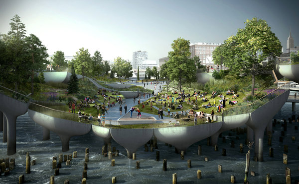
A rendering of Pier 55 which is expected to open in about four years. CreditPier55, Inc Heatherwick Studio
Pier 55 (former Pier 54) Who can forget Hurricane Sandy’s rampage through New York and New Jersey (Oct 29-30, 2012) that left behind a trail of destruction at the 5-mile long Hudson River Park on Manhattan’s West side, South Street Seaport and many other low-lying areas. Somehow, the disaster didn’t diminish the interest or enthusiasm of a New York power couple – Diane von Furstenberg and Barry Diller – from a location they had their eye on for a new signature park on the Hudson River. Pier 54 at West 13th Street has some history: it was the place that survivors of the Titanic were brought after their rescue in 1912. But the 875-foot pier has been largely shuttered and in a state of collapse– even though it had been a popular spot for movie screenings, concerts and temporary exhibitions.

Proposed site of new Pier 55. Note it is offset at an angle and will jut 186 feet into the river.
The couple started even before Sandy to consider how the pier might be transformed into multi-use cultural and public spaces. London’s Thomas Heatherwick is the architect who came up with the masterplan; New York landscape architecture firm of Matthews Nielsen (clients: Whitney Museum, Lincoln Center, St Paul’s Church near ground zero) is partnering with Heatherwick. Heatherwick is widely acknowledged for his Victorian style Rolling Bridge in London’s Paddington canal basin, the cauldron for the 2012 Olympics, and London’s just-approved Garden Bridge, a 375 meter wide landscaped bridge which at will span the Thames. See the Heatherwick video
The Diller-von Furstenberg Family Foundation has pledged up to up $113-million—of an estimated $130 million cost — to create a 2.4-acre island park by replacing the old pier: creating a rotated square will jut 186 feet into the Hudson at West 13th Street, with an amphitheater , piazza, landscaped knolls and public/performance spaces. As the New York Times reported, “Raising the pier above the new, post-Hurricane-Sandy flood plain allow[s] light underneath to improve fish habitats and offer views of the river and the skyline.” See the project video
Concerns have been raised about the project’s environmental impacts on the area, which is a designated estuarine habitat – for example installing 300 concrete piers into the water to hold the new park. A judge has ruled that an environmental impact assessment must be performed and project approved by the NY State Legislature before construction can begin. Expected completion date is 2018-19.
ROTTERDAM’S FLOATING FOREST

Floating forest for Rotterdam’s Rijnhaven neighborhood.
Rotterdam’s Bobbing Forest (Dobberend Bos) will become a reality this spring (March 2016) when 20 young trees are installed in floating containers – that look like buoys – to add appeal and whimsy to the Rijnhaven harbor. Sculptor Jorge Bakker hatched the idea and a committee of artists and designers proposed this installation – one of a series of floating art projects for the harbor. The idea of a floating forest – or park (see above New York’s piers) could help revitalize this neighborhood, not to mention cities like New Orleans and Miami where rising sea levels could jeopardize public space. Details
FREE SWIMMING IN BERLIN
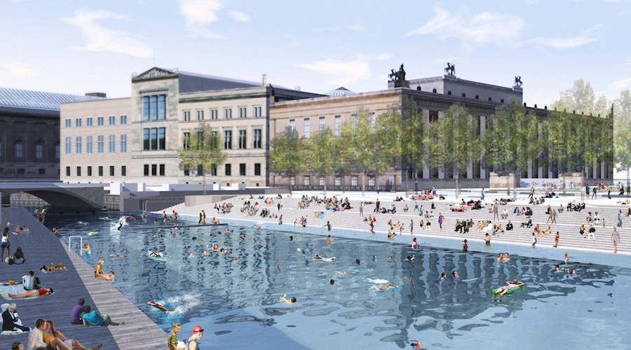
Artist rendering of Flussbad Canal in Berlin
Berlin is a surprisingly water-filled city– two dozen lakes and 45 kilometers of the Spree River –including a generous canal of the Spree that passes by Museum Island, a UNESCO World Heritage Site with five outstanding museums acknowledged for their architecture. The Spree is part of Germany’s inland waterway –and a transport netrwork – so it’s no surprise that it’s polluted. Some Berliners are eager to clean it up by creating a Flussbad (river pool) in the city center, between Schlossplatz and Bode-Museum, that would get rid of the pollution and provide a place for relaxing and fresh water swimming. Other cities have embraced the idea of open-air swimming holes (See our earlier coverage on Boston’s Charles River and Copenhagen open-water swimholes) The Berlin idea has been developing since the late 1990’s when brothers Tim and Jan Edler, whose design firm is Realities: United, started promoting their vision: a biotope (a natural habitat) with a gravel bottom and reed plantings that would filter the water and restore the ecological integrity as a wildlife refuge and place – over 800 meters in length running alongside the Museum Island – for people to swim. In other words, humanize a place that is formal and give it some “soul.” (See the Deutschwelle video)
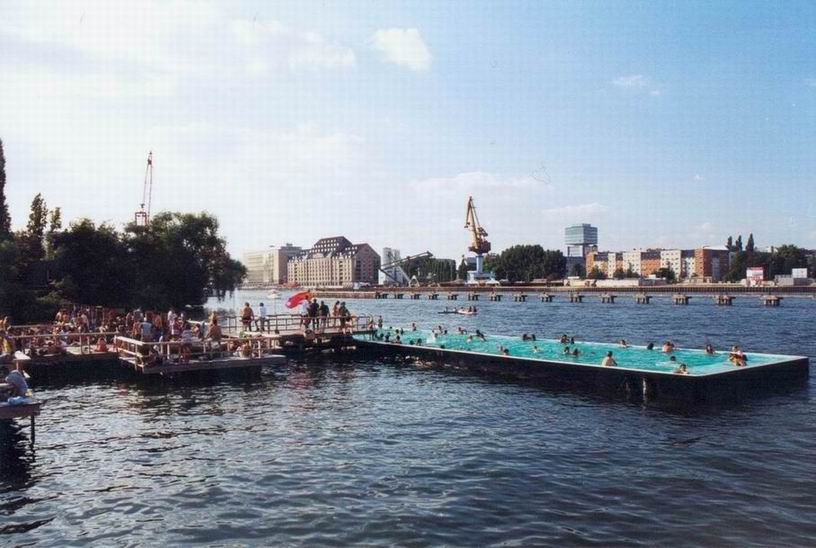
Temporary swimming barge in the Spree River, Berlin Germany
In 2011, the idea received the Holcim Award for Europe, which promotes sustainable urban development and outstanding architecture. The international publicity brought renewed attention, and formation of an official Flussbad Berlin association for the project. Enthusiastic advocate Gottfried Ludewig from the center-right Christian Democratic Union, is a young member of the Berlin City Parliament. He noted for the New York Times “Urban development and politics here should be like music in the city, where you have both the Philharmonic and nightclubs like Berghain,” Mr. Ludewig argued. “We should have Museum Island and also the Flussbad to show we’re still a city where crazy ideas can become reality.” On European River Swimming Day last summer – an annual event to raise awareness about pollution — about 100 people jumped into the canal for a dip (a few did get sick!).
REMAKING PHILLY’S WATERFRONT/CAMDEN TOO!

Philadelphia’s Delaware River Trail will provide a waterfront amenity for bicycling, walking and general recreation. Courtesy of DRWC
Tactical urbanism is one approach being used to achieve the $250-million, multi-year masterplan to remake Philadelphia’s Delaware River waterfront. That the term coined by Mike Lydon, co-author of the book Tactical Urbanism, in looking at how waterfront parks can be a tactical advantage in redevelopment.

Festival pier site is proposed for development. Courtesy of DRWC
Since the 1970’s and the advent of Penn’s Landing on the Delaware River, the City of Philadelphia has struggled to find an effective way to attract people – as well as developers and commercial traffic – to this part of the city. One big problem: the 10 lane I-95 highway that cuts through Philadelphia and makes it unpleasant to get the water. There were several efforts – including Penn’s Landing – but none of them stuck.
In 2009, the city formed the Delaware River Waterfront Corporation, a nonprofit organization to manage waterfront development. Then came the $250-million masterplan, with an ambitious set of proposals: to have a park every half mile along the waterfront, to trails, maritime, residential, retail, hotel and other improvements; and eventually create a sixth square in Philly by covering a portion of the I-95 highway that cuts through the city. Long story short: create a riverfront-friendly amenity that attracts people and investment.

Blue Cross Riverrink Park Photo by Matt Stanley
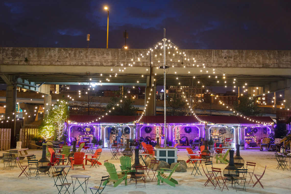
The tactical approaches have worked: An underutilized ice skating rink (near Spruce Street) was made into a winterfest location with the addition of lights, food and beer vendors, some events and performances. Now the RiverRink Winterfest has added a winter-themed lodge for those taking a break from skating or who just want to hang out (open through February 28).
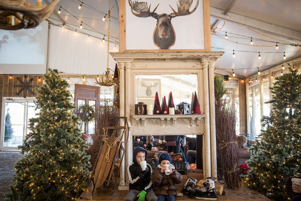
Winterfest lodge at the ice skating rink. Photo by Matt Stanley and Douglas Bovitt
Step two: a pop-up park started just a few blocks away as a summer urban “getaway.” The Spruce Street Harbor Park – a green space that was hardly used –became a summer venue assembled with a barebones budget: hammocks, lights, food and beer stand, and a floating beach – several barges covered in sand and decorated with beach chair – a Philly version of the Paris plages idea! The visitor count after three months was half a million!
Another park – one that extends into the river —Race Street Pier is a dual-level park in the shadow of the Ben Franklin Bridge. The lower level brings you close to the tidal level of the river; the upper level is perfect for picknicking and morning yoga classes (they’re free!) in warmer weather. The pier is landscaped with grasses, perennials and more than three-dozen trees cultivated in New Jersey for the World Trade Center Memorial at Ground Zero in New York City.
Race Street Pier in Philadelphia
Pier 68 opened October 2015, offers fishing, picnicking and recreation, and will be the southern entry for an even more ambitious project – the seven-mile-long Delaware River Trail.

Race Street Pier yoga session Photo by R Kennedy for Philadelphia Visitor Association
This incremental approach of waterfront improvement is made possible through a network of funders and partners, including William Penn Foundation, Philadelphia, the Pennsylvania Department of Community and Economic Development, the National Fish and Wildlife Foundation, and various companies with substantial commercial interests in the city.
Race Street Pier and Spruce Street Harbor Park have become highly popular venues that suggest other Philly piers may be turned into floating and landside parks to activate the waterfront. Read our article on Philadelphia’s waterfront makeover from 2014.
Follow the waterfront redevelopment on Twitter: http://twitter.com/visitphilly

Camden waterfront proposal
CAMDEN’S WATERFRONT: Philly’s “little sister” across the Delaware is Camden NJ, corporate headquarters of Campbell Soup and once rated the “most dangerous city in America.” New plans are underway for a mixed use development on the Delaware River waterfront that would add 1.7 million square feet of offices, apartments and retail space. This is a big deal for the city — inked by Camden’s Mayor and Liberty Property Trust as the developer with a $1 billion stake in the 16-acre waterfront area south of the Benjamin Franklin Bridge to Philadelphia. Liberty Property Trust is a $8-billion real estate investment trust which owns 106 million square feet of industrial and office space throughout the US and UK.

Liberty is looking for interested parties who will join the prioject and take advantage of tax credits through the New Jersey Economic Forum. This could be almost as satisfying as tomato soup on a cold winter day!
TORONTO WATERFRONT PLANS
Toronto’s waterfront is being reshaped in a 20-year plan – with $1.5 billion in start-up funding – to eliminate brownfields sites, create new neighborhoods and make the Lake Ontario shoreline a welcome place for strolling, bicycling and dining. West 8 + DTAH won the international competition for the Central Waterfront masterplan.
As West 8 describes the overall plan,
- The Primary Waterfront – a continuous water’s edge promenade, with a series of pedestrian bridges;
- The Secondary Waterfront – a recalibrated Queens Quay Boulevard with a new urban promenade and public spaces at the heads-of-slips;
- The Floating Waterfront – a series of floating elements that offer new boat moorings and public spaces in relation to the lake, and;
- The Cultures of the City – connections from Toronto’s diverse neighbourhoods towards the waterfront.

Queen’s Quay before…
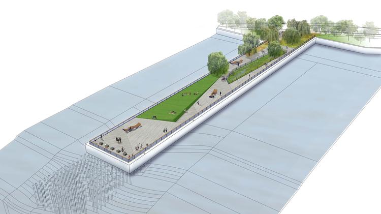
Completed in June 2015, the reinvented scenic pedestrian promenade –a major section of Queen’s Quay – hugs the shoreline and transforms the area as a complete street– pedestrian, bicycling, public transit, and conventional vehicles – and as a gateway to the Toronto Islands.

South side of Queen’s Quay at the Simcoe slip. What an improvement!
Once known primarily as an uninviting traffic artery, the vehicular path has been shifted to the north side, allowing for an ample and safer pedestrian promenade to the shoreline. The Quay was completely rebuilt with needed below-ground infrastructure (communications, electric, sanitary sewer, water lines), new road bed, and topped with a beautiful walking/cycling promenade that’s fitting for one of the city’s most visited areas. Some 2.5 million pieces of Canadian granite were laid along the promenade; 240 trees were added in Silva Cells, a modular suspended pavement system that uses soil volumes to support large tree growth.
The boulevard runs from Bathurst Street (central waterfront) to East Bayfront which boasts a new waterfront neighborhood (Waterfront Toronto).

A small section of the 650 meter ribbon passing through the crowd gathered at the 650-meter Simcoe Wave Deck. Photo credit CNW
This is not just a cosmetic makeover. The goal has been to improve traffic flow with features such as:
- Improving signal phasing and coordination to synchronize traffic at intersections
- Adding turning lanes and eliminating complicated u-turns
- Installing lay-bys on the side of the road for drop offs and pick ups
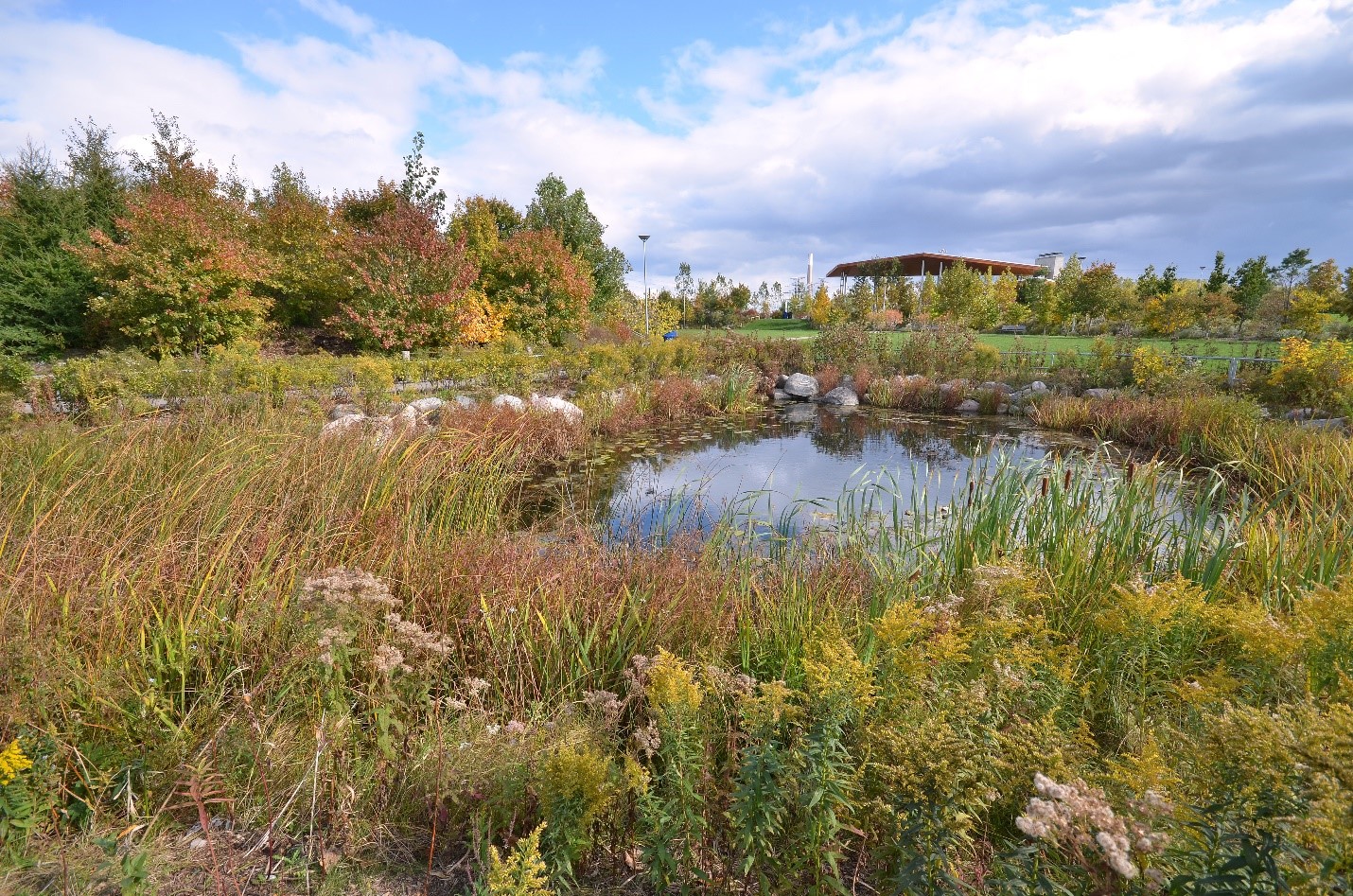
Corktown Common is a 210-hectare engineered site
And there’s a lot more underway including:
Plans to revitalize the Port Lands and naturalize the mouth of the Don River will incorporate climate positive strategies – such as green infrastructure, energy efficient buildings, renewable energy, and passive design. The 125-hectuare site will also feature new mixed-use communities around the new naturalized and flood-protected mouth of the Don River. Michael Van Valkenburgh Associates won the international competition for the masterplan. Follow the blog
KIRUNA’S ON THE MOVE

Kiruna Sweden, the current town.
Kiruna — the northern-most town in Sweden at 145 km above the Arctic Circle –shares snowy winters and the summer’s endless midnight sun with the indigenous Sami people, and has been inhabited in one way or another for 6000 years. It’s a gateway to vast uninhabited wilderness that attracts thousands of tourists annually. It’s also home of LKAB, a gigantic iron ore mining and extraction company. Kiruna is on the move – literally – over the next few decades, with a master plan to completely rebuild the community several kilometers east of its current location. Expansion of the LKAB operation under the town to extract coveted ore would have destabilized the current buildings and town. So the company is investing about 12 billion kroner to create a whole new town – with town center,square, municipal building, shopping areas, some 3,000 apartments, and cable lift transportation system. A few cherished historic buildings such as a 100-year-old church, will be disassembled and moved to the new location.

Kiruna proposed town center by White. Courtesy Arkitekter Dezeen
The firm Kjellander + Sjöberg has designed a compact town center that features a square, with streets that wrap around “like a cocoon.” (There’s an anthropologist on the team to interact with the residents and look at their memories and needs!) The design improves walkable access to shops and amenities, without getting in a car. And there will be pathways to walk to the nearby forest.

Masterplan shows proposed new downtown which will be built over the next few decades
The project includes some welcome “green features” – super insulated buildings, recycling of building materials from the old town teardown (it’s called the Portal), and reusing the former town site as parkland and a possible migration route for reindeer. Check out the video – there’s an anthropologist as part of the masterplan/design team – and photo gallery.
FLORENCE: REMEMBERING THE FLOOD OF 1956

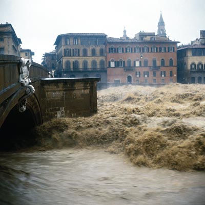
Arno River flooding at the Ponte Vecchio
Are you going to Florence this year ? The city’s devastating 1956 flood overran the banks of the Arno River, damaging the famed Ponte Vecchio, spreading water, fuel oil and mud over thousands of precious works of art, manuscripts and archival documents that have required a world community of art conservators to repair and restore over decades.

Exhausted volunteers at the biblioteca (Photo by Nicola)
This year marks the 60th anniversary of the flood, and the city will commemorate the events of ’56 with communications and cultural activities, and use the flood “as a starting point to deal with floods today, fostering measures based on respect for water, both as a resource and as a hazard, and on the growth of the culture of public health and safety.” The enormous damage wrought by the flood included precious works of art, frescoes, manuscripts and documents. Conservation specialists stepped up from all over the world — as well as countless volunteers– to assist in recovering and repairing the precious holdings. Read the story of the flood
Piazza Signoria Photo by Balthazar Korab
Gabinetto Vieusseux Library (Biblioteca del Gabinetto Vieusseux): All 250,000 volumes were damaged, including titles of romantic literature and Risorgimento history; submerged in water, they became swollen and distorted. Pages, separated from their text blocks, were found pressed upon the walls and ceiling of the building.
Located alongside the Arno River, the National Library was cut off from the rest of the city by the flood. The flood damaged 1.3 million items, including the majority of the works in the Palatine and Magliabechi collections, along with periodicals, newspapers, prints, maps and posters –a third of the library’s collections.
Archives of the Opera del Duomo (Archivio di Opera del Duomo): 6,000 volumes/documents and 55 illuminated manuscripts were damaged.
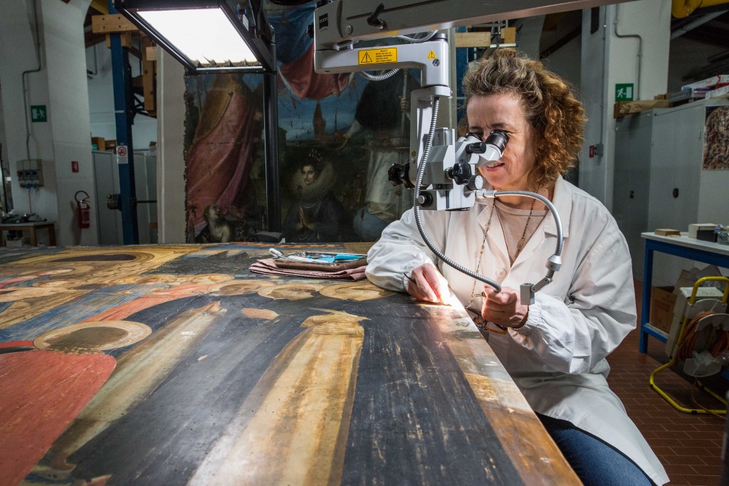
Caterina Toso cleans the San Marco Altarpiece, also known as Madonna and the Saints a painting on wood usually found in the Museum of San Marco in Florence. Commissioned by Cosimo di Medici, it was completed by Fra Angelico in the mid-15th century. Photo by Frank Carlson
The painted wood Crucifix by Giovanni Cimabue, the Father of Florentine Painting, in the Santa Croce Museum was considered the most important work seriously damaged. The water inside Santa Croce rose to 13 feet. The heavy wooden crucifix had taken on so much water that it had grown three inches and doubled its weight.
Florence is no stranger to flooding events: just last summer, a heavy storm pummeled the city and caused flooding in basements and loss of hundreds of trees.

New Yorker writer Adam Gopnik calls 423 Park Avenue (far left) “the tallest, ugliest, and among the most expensive residences in NYC’s history….an Oligarch’s Erection.” See Gopnik’s essay and review of books on urban design below. (Photo by Bobbie Faul-Zeitler CC: 3.0)
CITIES & THEIR DESIGN: BOOKS ROUND UP
The New Yorker writer-critic Adam Gopnik offers reviews and discourse on seven books that deal with cities and their design – two classics and the rest new offerings – that are worth considering if you love cities or have a role in how they are designed and function. He says, “ The two best books about American cities—Reyner Banham’s Los Angeles: The Architecture of Four Ecologies (1971) ]and Jane Jacobs’s The Death and Life of Great American Cities, which is essentially about New York—share an oddly double-headed ideology. Both Banham and Jacobs believe in unplanned, organic, emergent cities.” Read the essay and book reviews
Coming up: How you can participate in the Great Backyard Bird Count sponsored by the Cornell Ornithology Lab and Audubon, plus 5 things you can do for the birds in the winter!
